
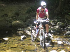
 I said I would go back to Waddell Creek and today I did :). This time we had plenty of time to do the whole trail. It's a fun track, very shady, and the creek is always nearby. An awesome area.
There are no long uphills or downhills and nothing too technical. There are some short steep sections that are challenging to climb and a blast to go down, but any of them can be walked up or down depending on skill level. The creek was a little high, but fordable. Although you can walk your bike on a footbridge if it wasn't.
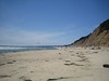
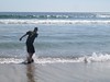
It was a great and sunny day. The trailhead is at the coast (see previous blog entry about the area) so we planned on a beach picnic at the end of our 11.8 mile (round trip) workout. Jalapeño cheddar sandwiches on the beach make for a nice reward :).
My GPS is on it's last breath it seems. The X-axis on the stick no longer functions, making it extremely difficult to navigate the menus (and impossible to save and then start a new track). So a new GPS may be in order.
The large redwoods and other trees made it really difficult to get an accurate GPS track, but I uploaded it anyways.


Click for Route:

No comments:
Post a Comment