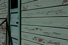
Month two was even harder than month one. There were many days that I just phoned it in and I struggled to take photos on some weekdays. It would be 10pm at night and I would still have no clue on what to take a photo of.
So I came up with an idea to theme my weekday photos and try to tie them together. I had a week of just dinners and a week where the subject was soft glowing light. Hopefully this should help me. I think I need to stay focused and make sure I'm not doing this as a chore but to represent my year as well as try new techniques and learn my camera.
I am happy to say that I am using my camera's manual mode more and more. There are times where I just don't like how the camera meters the light and I need more control. Even in Av mode I will use exposure lock more now than ever before.
Like last update, I went through and picked three of the photos I really like but did not include because another photo won out that day. This is kind of cheating, I know, but oh well :). I find ritually going back over a months worth of photos to find overlooked gems is encouraging and inspires me to do better.
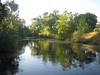
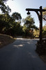
Did some light mountain biking yesterday at Alum Rock Park, one of the oldest (if not the oldest?) city park in the valley. It's fairly big in size and provides a decent amount of trail. It was really easy to get to which is good because even with the time change we were getting a late start. Plus everything seemed to be going wrong that morning, including someone stealing my bagel at the coffee shop. I'm surprised the bikes didn't fall off the Amigo.
We started at the parking lot just outside the gates and went up the main bike trail (marked Bicycle Path on the signs) that goes the length of the park. Donna's head started hurting so we stopped at the visitor center playground area for a rest and took some time to take some photos for my 365 project.
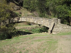
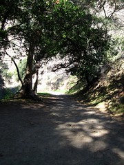
Donna not feeling up to it, I left my pack with her and continued along the main path until the end where it's open to horses and hikers only. Lots of old stone bridges line the trail and I almost regretted leaving my SLR with Donna (almost :), I still had my powershot). There is also a bunch of remains of old hot spring baths.
It's a pretty level trail, it's a very gradual uphill going in and a fun downhill going back. On a warm sunday the trail from the parking lot to the visitor center is pretty crowded so we had to take it slow on the way back or risk running into children :).
I would have liked to explore the other trails but we'll have to go back.
My Amigo is in the shop. I'm really thirsty for mountain biking, but it will have to wait until I can get my car back. My 365 Project (dubbed "thirty-one") has now gone on for 1 month and has kept me busy. It's cool to see the last month in photos and I feel like it's definitely helping me learn more about what I can do with my camera.
Some days (most days?) I really struggle coming up with a new photo and one or two of those days I think I've really phoned it in. I can't imagine what will happen when I run out of things inside my apartment to photograph. I need to take my camera everywhere I go, I suppose.
Other days I take so many photos that it becomes hard to choose just one. So I decided since it's been one month from when I started this thing I would create a flickr "reject" set and choose three of my favorite photos that didn't make it in.
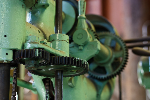
The first two of these three were taken on the very first day. I had about 4 or 5 photos I just could not choose between. I may have even chosen the wrong one :). I really liked this piece of machinery. I can't remember what the machine was anymore though:
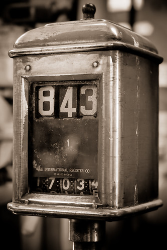
This photo looks good in color or duo-tone, but I like the contrast just a little bit better in the one without color. I'll probably say differently tomorrow:
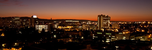
And last is a photo that I completely overlooked until today. The day I took this photo I put 4 photos to choose from side by side on my monitor and this was not one of them:
Been a crazy busy September, full of wedding venue visits, busy with work, etc. Haven't been able to get out much at all. Plus my Amigo needs some work done on him before I dare take him mountain biking.
September was also the month I started my 365 photo project. I'll post an update on that after 30 full days. It has really got me reading and thinking a lot about photography.
A quick background about me and photography: I love photography but have never really tried it until recently. I am especially a big fan of industrial and architectural photography (still or motion) from the early days of cameras. I love watching Edison's earliest films on the streets of New York.
In Manhattan about 4 years ago I purchased the book New York Changing: Revisiting Berenice Abbott's New York. It's a stunning photography book where the author recreates the setting of the 1930s photographs almost exactly and shows them side by side. He had figured out the exact perspective, the time of day, and even used the same camera so you can focus only on what has changed.
While I could never do it with the same precision, recreating old photographs seems like a great way to study perception and the difference between "zooming" in using greater focal length vs actually stepping forward.
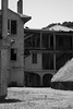
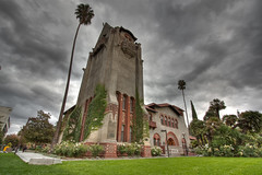
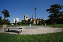
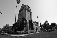
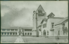
I wandered through the SJ Library's digital archive of their California Room looking for photos of San Jose and SJSU. I came across a circa 1915 photo of Tower Hall. I believe his would have been less than 10 years after it was constructed to replace the old building. Last Sunday I decided to shoot the building with every lens I had and also try to recreate the old photograph. Here are my results:
Obviously I didn't get it exact. I should have stepped more to the left and angled the camera more to the right and I was around 5 minutes too late for shadows. But I think it was a decent enough first attempt and a good learning experience.
Today I have started my 365 photo project. Many people seem to do these to document their year and use their camera more. I decided it was a good idea to learn my camera and force myself to get out there and take some photos. When I run out of ideas, hopefully I won't quit and it'll force me to be more creative.
The project starts today, on my thirty-first birthday and goes until my next birthday. I had a couple weeks to ponder this idea and I decided not to limit myself too much with rules. Since the idea is to try to become a better photographer, most of the exposures will be from my dSLR, but a point-and-shoot or cell phone will work in a pinch. When I'm done I hope to have a years worth of photos that kind of document my life.
They won't all be abstract like today's photo–which is from a set of photos I took at Kelley Park. I might photograph someone I met, a meal I really liked, things around my apartment, self portraits, etc.. I can also use it to test out photography techniques and such too. If I think of an idea or see a photo I would like to try to copy, I try to write it down.
There's a flickr set called "thirty-one" on my flickr photostream where I will upload them and the most recent photo will show up in the sidebar here. I will try to upload them once a day after I take them, but it might end up being every couple days.
This post should catch me all up :). Over this last weekend I did a two night backpacking trip in Point Reyes with Donna. August has been a crazy month of camping and backpacking and all the preparations in between. Great way to end the summer.
This would be Donna's second time backpacking. Her first trip was only 1.2 miles in, downhill, but with a ton of insects and generally not a very good experience (post 'Eaten Alive by Lions'). Lucky for me she was willing to give it a second try in a cooler coastal setting, but 4.6 miles to camp.
Taking off for Glen Camp at just before 5pm from the visitor center parking lot, the sun was still very hot. It was shady most of the way, but not breezy enough to keep from overheating. The first 1.5 miles is a very gradual uphill and then 1.5 miles of almost level downhill.
Three miles in the Glen Trail splits off and goes uphill steep. It was a little hard on the legs and the going was slow but I took comfort in the fact it was going to be nothing like the uphill I experienced in the Ventana Wilderness the weekend before. Plus hiking out from camp would be much more enjoyable than in.
We got to our camp with about 1 hour of daylight left to set up and cook. The campground has 12 sites, a water spout, and a pit toilet. There is a picnic table at each site, which was nice. Our camp was on a hill overlooking most of the other sites and surrounded by bush for a little privacy. It looked like one of the best sites there.
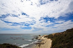
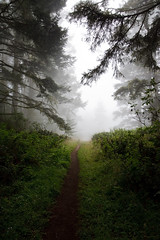
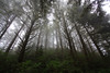
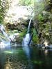
During the night we could feel the moisture in the air and I was either cold or very hot, there was no happy medium. We woke up to a ton of fog around us and in the trees. The fog never cleared during the trip, which made it a sort of strange fantasy land. We took off for a hike after 9 AM but the fog made it feel like it was hours earlier.
The photo at the top was taken during this trip. There is no color processing done to it and you can see what I mean by fantasy land. The hike took us to the coast and the area known as "Arch Rock" which you can supposedly get down to and walk through. It was near high tide and if there was any beach area it was now under water. We managed to climb down to the arch but the water was very violent moving through it and we could not get very close.
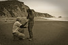
Determined to get to a beach we set off on another trail north, hoping the beach on my map was actually accessible. We were in luck. It was a small beach and very private. Nobody else was around. I took the opportunity to set up a tripod with the camera, turn it to auto fire, and propose to Donna on the beach.
I wasn't sure it would work out because moments after I set up, the tide came in and decided to try to help me level the sand around the tripod.
The entire weekend was perfect. Although the moisture in the air meant drying anything was near impossible, it kept us nice and cool.
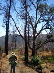
August 14-15th. Overnight backpacking trip I did with some friends. I think the idea was supposed to be just to try out backpacking and get out for a little while. We looked at the Ventana Wilderness for some possible short destinations and my printed map recommended Pine Valley as a popular trip so we agreed on that.
It was a pleasant enough trip overall. The trailhead was up a well maintained dirt road, and I always love driving on dirt roads in my Amigo, which we managed to get 4 guys and 4 backpacks into.
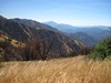
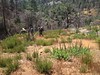
The trail itself is very exposed. There is a little to no shade the entire way. It follows a ridge which offers spectacular views of the wilderness around you. Most of the trees we passed were damaged by fire and dead. The trail into the campsite is nearly completely downhill and we knew that it was going to be a harder hike out, but I'm not sure we know just how much harder.
The campsite itself had a few people already there and visitors before us definitely didn't follow the "pack it out" philosophy. I guess it can be expected on a "popular destination". We managed to find a decent enough spot to set up camp and with plenty of daylight left we decided to continue down Pine Creek to the falls. They were less than a mile away so it shouldn't be too bad to get to, we thought.
Well the trail to the falls pretty much follows the river and requires a lot of scooting around on your butt or using your hands. It is debatable whether or not it is faster just to rock hop your way down the river. It was certainly more fun, until I tried to scoot down a slick rock, slipped and ended up on a water slide adventure that landed me in what I thought was a very small pool, maybe 2-3 feet in diameter.
I was fully expecting to find more rock a foot under the water I was sliding towards and I braced for impact. My feet went in, followed by my legs, my waist, and I nearly disappeared myself. I'm not quite sure if i ever touched the bottom or not, as I quickly pulled myself out, completely soaked up to my neck. The casualties in my pockets included a few jolly ranchers, a half eaten odwalla bar, and my company cell phone. Luckily the map, gps, and camera in my pockets were all waterproof.
The next morning we hiked out. Slowly. Check the elevation data in the GPS track below and you'll see how much fun we had. Add to that the facts that it was VERY hot, humid, I was pretty miserable from an allergy attack, and I had never ran out of water before in my life, so naturally this was to be the first time.
Despite the hell I went through to get back to the Amigo, I would do it again. This time with allergy medication.
July 31st to August 9th. Little late on the update, as it's been a busy month and took forever to go through all the photos (I'm still not done). Flew back to the SLC for my friend Nick's wedding and then we spent seven days camping in southern Utah. It was an awesome trip but much too short. I think I could spend months in southern Utah and not be satisfied.
I took hundreds of photos with two cameras, including my new Canon D10 which I had purchased as a camera that can be abused and be used in the water. I picked out 13 of my "keepers" and made a flickr set. The photo to the right might be my favorite one, its hard to choose. Most of the picks were from Bryce because it's very photogenic and the colors stand out really well on their own. I did the trip without a tripod (except a gorilla pod) and it finally convinced me I cannot keep hand-holding landscape shots, and need to give high priority to a packable tripod.
We spent 4 nights just outside the town of Escalante, in the petrified forest state park camp, and then 3 nights in a camground in Zion National Park in what might be the longest time I've spent living out of a tent in recent memory (there might have been some scout trips that were longer.)
It was a helluva trip with quite a bit of hiking. Hikes in the Escalante area included Calf Creek falls (the "utah-3" photo on the flickr set was during this hike) and the petrified forest loops. Most of the time it was insanely hot in the Escalante area, until the clouds and some light rain came in after our 3rd night.
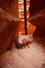
The original plan was to transfer camp to Bryce Canyon National Park, but we decided since it was close enough to our Escalante spot–which was uncrowded and had showers–that we'd just stay there and shuttle to the Park. At Bryce we combined the Navajo Loop hike with the Peekaboo Loop hike into a sort of figure-eight so we'd only have to hike down into the canyons once. It was a very scenic hike and all the Bryce photos in the flickr set came from this hike (6 to 11). It was so scenic we were probably spending too much time taking photos and had to pick up the pace to make it out of there in good time.
The only other hike we did in the Bryce area was the short Mossy Cave hike. Despite not living up to it's name, it was a good hike and included some more waterfall play.
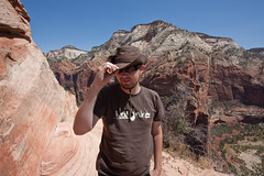
Packing up camp(in the rain), we moved on to Zion National Park, the entire reason we planned the trip. We managed to secure a backcountry permit for hiking the zion canyon narrows from top to bottom, a 16 mile hike through–as the name implies–narrow river canyons. It starts out crossing the river what feels like a hundred times and the last three miles are so narrow, with 1200 canyon feet walls on both sides of you, and nowhere to hide from a flash flood. At this point you are no longer crossing the river but wading through the river, sometimes waist deep, and over slick polished rocks.
I've done the hike before with my father about 10 years before (maybe to the day) and he describes the last three miles as "amazing and beautiful but walking on wet bowling balls never ends and you just become annoyed" and that still seems true to me too. It's a wonderful hike and I'd do it every year if I could. This time the water was much higher than it was 10 years ago and there was some spots where swimming was necessary.
Donna is turning out to be an amazing sport when it comes to following me around and trying out some of my hobbies and this is by far the most adventurous thing I have put her through. She was quite shaky with all the slippery river wading and crossings and we had to take our time with them, but she was getting it down towards the end.
It was a near-perfect trip and I wish i could do it all over again. It was a much needed vacation from work and much better than spending it at a resort or in a hotel. I can't think of many things I'd rather do than spend a week in a tent in the Colorado Plateau. I've been to Zion a few times already and it still meets my expectations and beats any of the other amazing places I've visited this year, and that includes Big Sur.
Late on updates this month. It's been a crazy month, with a 10 day trip to Utah on July 31st, and then two backpacking trips. One of which I got engaged on. :) Hopefully there will be updates soon.
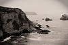
Did a little car camping in Big Sur over the weekend. It was pretty fun and easily one of the best places I've ever been. It is certainly my favorite place in California so far. I can't believe it took me 3 years to get there.
I have a flickr photo set of my favorite photos. Still learning the best settings to use when, but I have yet to use auto or even program mode on my camera in a while now. It gets a little discouraging when a photo taken with mine or my girlfriend's Elph looks just as good or better though. Processing RAW photos properly without spending a lot of time is still a challenge.
In the last week I've doubled the amount of lenses I own. When I bought my dSLR in December as a Christmas gift to myself :), I expected it to become a limited hobby. Turns out every time I go out for a photo shoot I come back disappointed in one aspect or another and end up buying another piece of equipment.
My kit lens (18-55) and my telephoto zoom (55-250) have served me well since then but I have added a fast (but extremely fragile and cheap) Canon EF 50mm f/1.8 prime and my girlfriend surprised me with a gift of a Canon EF-S 10-22mm wide-angle zooms lens.
By no end do I claim to know what I'm doing when it comes to photography, as I am just starting out. The geek in me quickly takes the new prime lens, shoots a bunch of photos at various apertures, and then compares the EXIF data. Here is a flickr set of my test shots with both lenses. Check them out in the slideshow or click to go to flickr and read the captions:
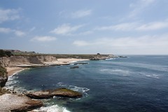
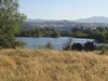
With the day off on Friday we decided to head to Wilder Ranch for some coastal biking. I had mapped out a trail starting from the parking lot to the coast, along the coast for a few miles, and then back inland to a supposed tunnel that takes you across highway 1.
The temperature was near perfect while riding and the coastline was beautiful. It's an easy trail that would be perfect for anyone. We ended up going 14.25 miles total, but if I was to ride this again I would turn around near the last beach unless I am in need of more exercise.
The trail is supposed to go down to the first beach and then back up to the bluffs on the other side unless there is high tide. You can see a photo of a nice couple taking their bikes down (Sorry guys I forgot your names. Duffy? So I hope you find this photo of you below somehow :) ). Unfortunately we soon found out that a large puddle was preventing us from getting to the trail on the other side. A hiker would have no problems, but getting the bike across looked messy and wet.
We took our bikes down anyways for photos, and then came backup the path we came. The detour added a couple miles to the trip.
Some of the trail was extremely grassy, to the point you had just keep spinning the tires. My chain picked up a lot of grass which you can see in the photo.
I had my kit lens and a new wide-angle lens for photos but I had skimped on a tripod and my telephoto lens and regretted both. I had my gorilla-pod but no real trees or rocks to attach it to. I would have really liked to have a lightweight full size tripod for some sharper shots.
It was a wonderful day which ended in a trip to Santa Cruz for a beer and shopping. I picked up some wonderful new flip-flops to replace my $7 Tevas I bought in 2005.
I will post some more photos when I finally wade through them all and pick my favorites.
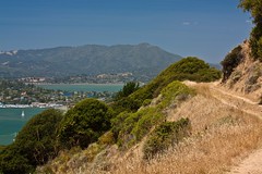
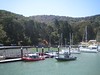
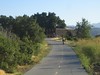
Sunday we took our bikes to Angel Island for a ride just under 10 miles long. We left early morning to drive to Tiburon and then caught the ferry to the island.
We took the perimeter (paved) road around clockwise so we could hop onto the inner road early in the trip. It was a decent climb to a dirt fire road that loops around the inner part of the island. After completing that loop we dropped back down to the perimeter road and completed that.
This is easily one of the most scenic bike rides I've done. No matter where you were on the trail there was a view of the bay. The weather was perfect. It was a great day. There was a few tourists there but they all pretty much stayed on the perimeter road.
We took our time on the trails and took a ton of photos. By the time we got back to Tiburon the tourist rush was gone and getting a shady patio seat at a restaurant there was extremely easy.
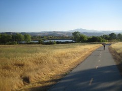
In an effort to get out during the week, we attempted the Coyote Creek trail after work last night. This time we went a total of 25.5 miles. Still 5 miles (round trip) short of the end, but we had to make it back by sunset. The return trip should have been a slight downhill but with a head wind it actually took off almost 2 mph, making it feel as if it was uphill in both directions.
It's a nice parkway with lots of shade. The new parts for us were mostly in old ranch land and preserved areas and very pretty. There are even rest stops along the way. We made use of one just after turning around so we could get a bite to eat. The only thing that would make this trail better is if it was single track :).

 Month two was even harder than month one. There were many days that I just phoned it in and I struggled to take photos on some weekdays. It would be 10pm at night and I would still have no clue on what to take a photo of.
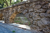


 Late on updates this month. It's been a crazy month, with a 10 day trip to Utah on July 31st, and then two backpacking trips. One of which I got engaged on. :) Hopefully there will be updates soon.